
Whitney Neighbors by Block Source
Public records can describe the parcels around a Whitney address, but each source has a limited role. The map is best for physical adjacency. The Assessor and Treasurer provide parcel and billing context. The Recorder provides document relationships. Civic records can show a meeting item or public agency contact, not a list of every neighbor. Start with the source that matches the question, then keep an APN, date, and source link in the record note.
| Block source | What it can show about Whitney neighbors | Access route |
|---|---|---|
| GIS OpenWeb | Subject parcel, adjacent parcel geometry, site address, map and legal context | County reference viewer |
| Assessor | APN, situs, owner or mailing fields, appraisal context | County real-property search |
| Treasurer | Parcel, name, situs, mailing address, fiscal-year tax fields | County tax-statement search |
| Recorder | Instrument parties, dates, legal descriptions, parcel and name searches | Public index and copy routes |
| Whitney TAB | Agendas, minutes, audio, public projects, and civic contacts | County civic-record page |
A person shown in one of these records might be an owner, correspondent, public speaker, or document party. The label matters. Use a dated, independent historical source before claiming that a person was present at a Whitney address during a particular period.
Whitney Neighbors Start With APNs
An APN, or assessor parcel number, is the stable bridge for a block search. Begin by locating the subject address in the Assessor or GIS system. Record the APN in both hyphenated and unhyphenated formats, the displayed site address, and the map date or aerial date when shown. Then identify the polygons that actually meet the subject parcel. That is a physical-neighbor question, not a same-street or same-ZIP assumption.
- Find the subject address and confirm its APN and situs address.
- Use the GIS parcel boundary to note each adjacent APN and any street-facing address shown by the county layer.
- Open one adjacent parcel at a time and record only the parcel fields needed for the question.
- Use the Assessor, Treasurer, or Recorder link associated with that parcel when a source-specific check is needed.
- For a whole road rather than an immediate block, continue with the Whitney street directory address workflow.
Parcel lines are not an association boundary, town boundary, school area, or voting precinct. A shared street name can be useful for orientation, but the map geometry defines the immediate parcel relationship.
Whitney Neighbor Parcels in OpenWeb
Clark County GIS OpenWeb combines a map with property links. A selected parcel can show owner name fields, site address, jurisdiction, sale date and price, estimated lot size, construction year, recorded-document number, aerial-flight date, application or zoning fields, land-use-plan area, subdivision, lot or block, T-R-S, flood information, elected officials, and links to Assessor, Treasurer, Recorder, parcel-map, and APN-tree services. That makes it useful for placing an address in a block context before seeking a document.
The GIS OpenWeb parcel viewer is the county source represented in this capture.
OpenWeb is a reference layer and carries a data disclaimer. Its sample parcel metadata includes CC Whitney - 89122, Whitney land-use-plan area, T-R-S 21-62-27, and FEMA panel 2583 with the zone blank. Those are sample values, not a template for every Whitney parcel. Confirm a title issue against a recorded instrument and date.
Open Each Whitney Neighbor Parcel
Do not copy a cluster of names from a map. Open a neighboring parcel only after the geometry shows why it relates to the subject parcel. OpenWeb’s property links create a cleaner path: the Assessor describes the appraisal and parcel record, the Treasurer shows the tax-account context, and the Recorder index points to a documented event. Capture the field label that supports each statement, rather than relabeling every name as a neighbor.
The parcel-specific GIS view illustrates how a selected record can lead to an adjacent-parcel context.
Use the source’s displayed parcel number and retrieval date when moving between systems. A map owner field can lag, normalize a name differently, or represent common land. A Recorder image is the better source for a recorded transfer, while a tax statement is the better source for a fiscal-year billing view.
The inspected GIS interface also has a map-measurement tool and a 100-foot scale control. Record the layer name, aerial date, and whether the map is current before comparing parcels. A measured distance can help describe map context, but it cannot replace a surveyed boundary or a recorded plat.
Whitney Neighbors Need Relationship Labels
Same subdivision, same ZIP, same tax district, and adjacent parcel are different relationships. Two addresses can share 89122 yet be separated by a large area. Two parcels can share a tax district without touching. A common subdivision label can include streets that do not border one another. In contrast, a parcel that shares a boundary with the subject APN is physically adjacent, though it may be common land rather than an individual situs.
The county free-map collection offers ZIP Code Boundary, Whitney Town Advisory Board, Commission District, and Las Vegas Valley Street Map layers. Those layers add civic or delivery context, not proof of who is present at a location. For a current voter question, the county’s individual voter service is identity-gated and voter-list access has separate statutory rules. A precinct is useful for a civic question, not a substitute for a parcel boundary.
Whitney Neighbor Mailing Context
A mailing address can point outside the immediate block. The Assessor sample card for APN 161-27-621-051 shows the categories used by the county: owner and mailing address, location address, City/Unincorporated Town, assessor description, recorded-document number, recorded date, vesting, tax district, and assessed-value fields. The sample also illustrates why a mailing city should not be treated as a parcel’s situs.
The Assessor parcel-card example shows the distinction between parcel fields and tax or mailing information.
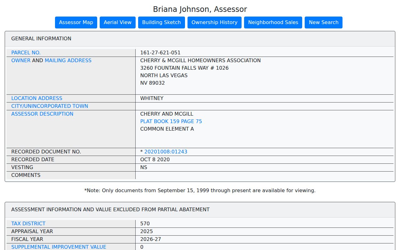
An association, trust, organization, or outside-city mailing entry can be valid for a property record. It does not identify a household at the physical address. Keep the situs and mailing fields distinct, and use a dated source before making any historical connection.
Note: An Assessor current or prior-owner display is a useful lead, but the Recorder instrument is needed for a full recorded-property chain.
Whitney Neighbor Planning Edges
Block context changes at a planning edge. The Whitney planned-land-use map was adopted November 17, 2021 and amended July 22, 2024. It distinguishes Neighborhood categories such as ON, EN, RN, LN, MN, CN, and UN; commercial or mixed-use categories NC, CM, and EM; BE and IE categories; and other planning categories. These codes describe planning uses, not household types or a neighbor list.
Boulder Highway and Tropicana are major corridor references. Las Vegas Wash and Clark County Wetlands Park help orient the developed area west of the Wash. The Whitney planning geography also contains two unincorporated county islands inside Henderson, including the Tronox or former Black Mountain Industrial Complex area. A parcel being in the Whitney planning area does not make it part of the City of Henderson, and a nearby landmark does not establish a parcel boundary. Use the county map layer for the exact question.
Whitney Civic Neighbors and TAB Records
Whitney Town Advisory Board records add civic context to a block question. The board is a conduit between the community and County Commission under the Open Meeting Law framework. Its agendas, minutes, and audio can be searched by street, APN, development name, road, zoning matter, or meeting date. A speaker or applicant in a meeting record is connected to that public agenda item, not automatically to a Whitney residence.
| Whitney civic source | Contact or record path | What it does not provide |
|---|---|---|
| Whitney TAB | Agendas, minutes, audio, and posted county contact information | A formal household or association-member directory |
| TAB/CAC information | County explanation of the advisory role and public-meeting framework | A parcel-owner or resident roll |
| Formal association directory | No public Whitney-wide directory was located in the reviewed sources | Evidence that an association, contact, or member list does not exist |
The TAB meets at the Whitney Recreation Center on Missouri Avenue according to the county page. The posted schedule places meetings on Thursdays before the first and third Tuesdays at 6:00 p.m., with agendas available at the Whitney Senior Center. Use the meeting date and agenda item when citing a civic record. It is safer and more accurate than treating a civic appearance as a personal-directory entry.
Privacy Limits for Whitney Neighbors
Official property and civic sources have provenance and defined fields. Commercial neighbor-lookup categories may merge old or unclear data from different sources. Neither category proves a complete household, current presence, or a personal relationship. Use a source only for the narrow relationship it documents, and avoid building a dossier from parcel, voter, court, custody, business, and social records.
| Source category | Useful evidence | Necessary limit |
|---|---|---|
| Official county records | APN, site or mailing field, dated instrument, map geometry, or agenda item | Each field has a specific relationship and may change. |
| Commercial neighbor-lookup tools | A possible lead to verify elsewhere | Do not assume the data is current, complete, or authoritative. |
Nevada Public Records Law does not override confidentiality statutes. NRS 293.558 protects voter authentication data and allows address and phone withholding. Nevada Confidential Address Program participants can use protected records under NRS 217.462 through 217.471. Keep only the parcel or record details needed for a specific historical or civic question, and use the official privacy or withholding channel where it applies.
Lawful use. A Whitney neighbor search should stay focused and lawful. Never use parcel maps, mailing fields, or public records to stalk, harass, intimidate, or harm another person.