
Follow a Whitney Street Address
Use the Whitney street directory as an address trail, not as a single list of everyone on a road. Clark County holds the key records because Whitney is an unincorporated town. An exact address can lead to a parcel number, also called an APN, then to map, tax, and recorded-document sources. The chain can identify a current parcel relationship or support an older address question. It does not, by itself, establish a complete household.
- Standardize the address with USPS ZIP Code Lookup. Keep the unit, direction, street type, and any older spelling in the research note.
- Enter the normalized address in the Clark County Assessor address search to obtain the parcel number and legal City/Town context.
- Open the same APN in Clark County GIS OpenWeb. Check the site address, parcel shape, lot or subdivision details, and the parcels directly beside it.
- Use the Treasurer tax statement for its dated situs and mailing fields. A tax bill is a billing record, not a title opinion.
- Search the Clark County Recorder index by parcel, instrument, name, or legal description. Read the dated instrument when a title question matters.
The result should be labeled precisely: parcel owner, deed party, tax-mail recipient, or historical directory listing. For a full block question, use the parcel geometry first, then move outward one adjacent APN at a time.
Whitney Street Fields at the Assessor
The Assessor address form is the practical first stop for a Whitney street directory query. It separates street number, direction, name, type, and legal City/Town. That separation matters around Whitney because a delivery label can differ from the county legal-boundary choice. The interface also reports that an address entry can search within three blocks, which can help when a number is missing or a segment has changed. Save the returned APN in both hyphenated and unhyphenated form for later county searches.
| Assessor field | How to use it | Whitney record note |
|---|---|---|
| Street Number | Enter the situs number first. | Try the nearby-result behavior before changing a street name. |
| Direction and Street Name | Keep the directional prefix and spelling separate. | Do not merge an older street form into a modern one without proof. |
| Street Type | Use the type shown in the address, such as avenue or road. | A suffix mismatch can hide an address result. |
| City/Town | Select the legal county value expected by the form. | It is not a substitute for a mailing-city field. |
| Current or Prior Owner | Choose the available owner-history preference when relevant. | It is a starting point, not a complete deed chain. |
The Assessor address-search screen shows the address controls used to begin that chain.
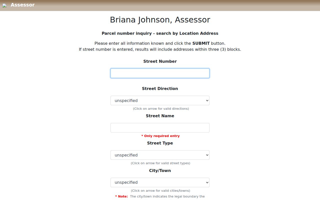
Once the form returns a parcel, the APN is more durable than a casual street-name match because it links the Assessor, GIS, Treasurer, parcel-map, and Recorder systems.
Note: A street result identifies a parcel record, not every person who may be connected with that address.
Read Whitney Streets by Parcel
OpenWeb adds the spatial part of a street directory search. A selected parcel can display owner name fields, site address, jurisdiction, sale date and price, estimated lot size, construction year, recorded-document number, aerial-flight date, land-use plan area, legal description, flood information, elected-official information, and links to other county systems. The map is especially useful for frontage, lot and block context, and the APNs that physically touch the subject parcel.
Its values are reference data. The GIS sample shows a jurisdiction formatted as CC Whitney - 89122, a Whitney land-use-plan area, T-R-S 21-62-27, and a FEMA panel value. Those are fields from one captured record, not universal facts about every Whitney parcel. OpenWeb carries a data/reference-only disclaimer, so a current ownership or title conclusion needs confirmation from the relevant recorded document.
Use the map geometry to answer a narrow question. A parcel behind an address may be adjacent even if it is not on the same named street. Conversely, two locations with the same street or ZIP may be separated by other parcels and are not necessarily adjoining.
Whitney Street Record Coverage
Several county systems can be keyed to a Whitney address, but their evidence is not interchangeable. The strongest record trail keeps a source date and relationship label beside each result. The following coverage shows what a street search can reasonably retrieve and where a second check is needed.
| Address record | County keeper | Street-level evidence | Best use |
|---|---|---|---|
| Real-property record | Assessor | APN, situs, owner or mailing fields, appraisal context | Turn an address into a parcel. |
| Parcel map | GIS OpenWeb | Geometry, adjacent APNs, legal and map context | Check street frontage and physical adjacency. |
| Tax statement | Treasurer | Parcel, name, situs, mailing address, fiscal-year view | Separate billing address from situs. |
| Recorded instruments | Recorder | Document parties, dates, instrument and legal-description routes | Verify a recorded property event. |
| Building records | Building & Fire Prevention | Document images, inspection history, permits, job cards | Build a structure timeline where records exist. |
For a time-bounded household question, add a dated directory, newspaper, census, election-history, or other independent source. A current parcel owner is not automatically a present occupant, and a recorded party is not automatically a resident.
Whitney Street Mailing Labels
A mailing city is not the legal town designation. The Assessor’s City/Town selection is a legal-boundary control, while a parcel card or tax statement can show a mailing address in Las Vegas or North Las Vegas. GIS can simultaneously identify the jurisdiction as CC Whitney. These fields can all be accurate because they describe different relationships: legal geography, postal delivery, tax correspondence, and parcel location.
Keep the site address and mailing address in separate columns. A homeowners association or other organization may receive mail for a parcel, particularly common land or an association-related record. That tells the reader where correspondence goes, not who is present at the street address. The same caution applies to a document party or a name in a tax field.
For an exact delivery question, preserve the USPS-standardized address and ZIP or ZIP+4 separately from the county parcel result. The official county ZIP map is a display map created January 3, 2019, while the current GIS layer supplies parcel context. Neither one turns a postal city into a legal-town determination. Compare the exact address, APN, and map layer before assigning an address to Whitney.
Whitney Streets on a Planning Map
The official Whitney planned-land-use map is a useful street index for local orientation. It was adopted November 17, 2021 and amended July 22, 2024, so note that version whenever a parcel is connected to a planning category. The map labels corridors and cross streets including Boulder Highway, Tropicana, E Charleston, E Sahara, Flamingo, Russell, Lake Mead, Nellis, Lamb, and Mountain Vista.
The county Master Plan describes the Las Vegas Valley square-mile grid and distinguishes arterial, collector, and local streets in planning terms. That background helps explain a cross-street description, but it does not establish a legal width for a particular segment or a postal boundary. Street presence on the planning map also does not guarantee that every address along it shares one ZIP or mailing city.
Fire Station 17 at 5702 Missouri offers a useful fixed-address history lead. County fire history identifies Whitney Volunteer Fire Department service before 1962, county remodeling in 1961 and 1962, and later sheriff-station use. Search that address with its contemporary East Las Vegas label in dated county materials and newspapers rather than treating one modern map label as the full history.
Whitney Street Deed History
The Recorder supplies the document side of a Whitney street directory search. AcclaimWeb offers Simple Search, Name, Parcel Number, Instrument Number, Document Type, Book/Page, Record Date, Total Value, Legal Description, and Help. In a name search, Last Name is required for a person; First Name is optional; the mode can be starts with, contains, or exact; and the search has book type, date-range, show-names, and document-type controls. Search surname variants or a company name before narrowing a date range.
The Recorder name-index screen illustrates the available search modes and filters.
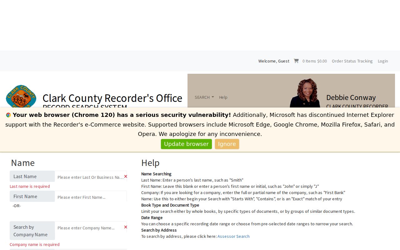
The public result is an index summary. Original images are viewed in the Recorder public research area or ordered through the county, and the online Official Records index begins in 1988. The Recorder says microfilm reaches back to Clark County’s 1909 beginning. For an earlier event, ask for an index or microfilm search using an approximate year plus APN, plat or legal-description details, and grantor or grantee variants.
Note: A deed identifies a recorded property relationship and date; it does not prove that a party lived at the situs.
Whitney Street Names Through Time
Historical street research needs the name that the source used. Whitney was called East Las Vegas from October 1958 through August 1993, after the unincorporated Town of Whitney had been created. Search Whitney, East Las Vegas, and East Las Vegas Township when working with newspapers, election scans, permits, fire history, directories, or plats. Do not silently rewrite an older address into a current label.
For street-by-street leads, UNLV identifies a 1975 Las Vegas Valley street-directory subject file, and its Regional History Files finding aid identifies a verified 1969 Las Vegas city directory. The Library District genealogy collection can add newspapers, obituaries, land, court, tax, and directory sources. These are selected regional holdings, not a continuous official Whitney directory run. Record the year, source scope, whether a page or image was seen, and the street spelling before drawing a historical conclusion.
No official year-by-year Whitney street-renumbering or street-name conversion table was located. When an older number does not map cleanly, work from the legal description, plat book and page, APN tree, and dated map before deciding that two addresses are the same place. A focused county request can name the exact address or APN, record class, and date range, rather than seeking a broad list of people.
Whitney Street Record Terms
Small label differences can change the meaning of a Whitney street result. Use the county field names as written and retain the source URL and retrieval date with the result.
- APN
- The assessor parcel number, an 11-digit bridge among the Assessor, GIS, Treasurer, and Recorder systems.
- Situs address
- The physical property location used in a parcel or tax record. It can differ from a mailing address.
- Legal description
- A recorded land description, often using subdivision, lot, block, plat, or survey details. It can bridge an older address change.
- Plat
- A recorded subdivision or parcel map. It helps locate lots where a street name or number is uncertain.
- Criss-cross directory
- An address-arranged directory that may place a name at a street address for a stated publication year.
Limits of a Whitney Street Directory
No public county source is a complete roll of every household along a Whitney street. Parcel records describe property and tax relationships. Deed indexes identify document parties. GIS is a reference layer. Voter services have a separate access model, identity-gated individual service, statutory list rules, and protected fields. Utility accounts, delivery records, protected addresses, sealed court material, and vital-record information are not a general street-search resource.
Nevada confidentiality rules remain in force even where other records are public. NRS 293.558 protects voter authentication information and allows address and phone withholding. The Nevada Confidential Address Program under NRS 217.462 through 217.471 protects qualifying participants. Keep only the APN, record category, instrument or case number, source, date, and relationship needed for a specific historical or civic question.
Lawful use. Use Whitney address records for a focused, lawful purpose. Never use a parcel, map, or document trail to stalk, harass, intimidate, or harm another person; that conduct can violate Nevada law.